Welcome (back I hope!) to Lavalhallalujah, the blog that researches, interprets and promotes the distinct plausibility that Norse expeditions to North America (985-1010AD) – led by Bjarni Herjolfsson, Leif and Thorvald Eiriksson, Thorfinn Karlsefni and Freydis Eiriksdottir – explored and mapped what would later become known as ‘French Canada’, including the shorelines of the Gulf of St. Lawrence and up, way up the St. Lawrence River.

Norse maps of those expeditions were evidently recorded and shared, not on paper, but through the spoken word. Segments of The Vinland Sagas have been emerging since 2013, based on satellite imagery and local photo research, as sailing directions, laid out through oral storytelling. Wonderful ‘double-entendres’ that both describe the natural details along routes to and from Norse settlements in Helluland, Markland and Vinland, and record the dramatic history of events of the Norse colonization attempts in North America.

As with my last post, this blog is not a new entry, but an update of my original December 2013 “Red Cloth Unravelled” post. More a photo essay, the 2013 blog was published to officially mark my newly discovered ‘Skraelings are (also) Trolls’ interpretive match between: the distinct red ‘sinuous infolding‘ rock that stretches for kilometres along the shoreline of L’Ile Verte, Quebec (below); and, the matching details spoken of in The Vinland Saga that record Thorfinn Karlsefni trading red cloth with the local “Skraelings”, the First Nations peoples.

As one moves upriver, the very visible widths of red and grey stripes in the shoreline rock along L’Ile Verte, shrink in unison with the spoken words in the Saga. Very soon afterwards another match, a beachfront Skraeling face in stone, with a large stripe of red cloth around its head. Following that, kilometres upstream at Ste. Andre, Quebec, a natural palisade bounds like The Vinland Saga’s “bellowing bull” out onto the flat, fertile farmland between the Appalachians and the shoreline of the St. Lawrence River.
With so many direct, distinct geographical and Vinland Saga matches, in a row along the Ile Verte shoreline, it became clear to me in December 2013 that the long-unidentified “Skraelings” of The Vinland Sagas were in fact, for the purpose of Norse mapping, mountain-based, troll-like ‘beings’ – much like the trolls found living within boulders, crevices, cliffs and mountainsides within Icelandic spiritual beliefs, to this day.

In the red cloth Saga, The Skraelings emerge as do the Appalachian mountains that extend to the tip of the Gaspe peninsula. In other Sagas, the Norse encounter Skraelings as they approach Newfoundland’s Long Range Mountains, Quebec’s Laurentiens, Mount Royal and Gatineau Hills, and the Appalachians in north New York state.

Through 2014 and 2015, I continued to match geography with The Vinland Sagas, soon interpreting the “boats” and “sticks waving” in the Karlsefni Sagas as signifiers of islands, and pointes. Research followed into marsh hay cord grass (Vinland’s “self-sowing wheat“) that led to matching the Sagas’ location of the Norse settlement of “Hop,” at Barachois Pond in southwest Newfoundland – in the same stretch Sarah Parcak found potential evidence of a Norse presence at Point Rosee.
Then finally, with the second “headland” in the red cloth Saga still to be found, I took an October 2016 bike ride around Ile d’Orleans, Quebec (my suspected “Straumfjord”). There, off the northeastern tip of the island, it became easy to conclude with confidence my “red cloth” oral map interpretation, with the sight of the unmistakable second “headland” spoken of: Cap Tourmente, Quebec.
Here’s how Thorfinn Karlsefni’s “Red Cloth Saga” (c. 1010AD), weaves together both the Norse history of explorations in North America, and sailing directions from “Hop”, out Newfoundland’s St. George’s Bay, “south” across the Gulf of St Lawrence, and up the St. Lawrence River estuary to “Straumfjord”:

“Then, early one morning in spring, they saw a great horde of skin-boats approaching from the south”,
The Saga/map begins after a winter’s stayover at The Vinland Sagas’ settlement of “Hop” (Barachois Pond, Newfoundland). The Karlsefni expedition sets out in the spring, “south” out of St. George’s Bay – using Point Rosee as bearings – across open water toward Les Ile de la Madeleine. The word “horde” is used here to describe the collection of low-lying islands that make up Les Iles de la Madeleine, all linked by sandbars. The stress of the unexpected encounter advises map followers to steer away from the islands, and head for Gaspe, Quebec.
“round the headland”.
Then, it’s up and around the first “headland”, the Gaspe peninsula (the northeast tip of the Appalachian mountain range), past the Norse settlement of Kjalarness. Following the shoreline “south”, the oral map brings one to the entrance of the St. Lawrence River estuary.

“So dense that it looked as if the estuary were strewn with charcoal.”
On cue at Saint-Maxime-du-Mont-Louis, Quebec, the Sagas’ words describe an estuary perfectly matched with the very (very) distinct local geology: a unique charcoal-black cliff face, and black rock slides that follow. All add up to making the entrance into the St. Lawrence River estuary look very much like it is “strewn with charcoal”.

Again, one must take into account, always, the Icelandic (Norse/Greenlander) cultural belief in ‘trolls’. The Vinland Sagas use trolls’ characteristic rock, hill and mountainside abodes to map sites in the new world – making recognizable landmarks where the earth has erupted in highly distinct shoreline peaks, crevices, cracks and colours. Here, along this stretch of the Gaspe peninsula, the spectacular topography is described by The Bicyclist on his cycling blog as “sedimentary rock that has been lifted, sometimes 60 degrees, in some ancient upheaval.”

“And sticks were being waved from every boat.”
In The Vinland Sagas, natural features become the tools of the Skraelings, and the Sagas speak twice of the “sticks” they wave from their “boats”. Here the keel of ‘Kjalarness’ (Gaspe) is mentioned, then ‘La Tourelle’ a very distinctive paddle-shaped rock formation at Haute Gaspésie. All is a description of the numerous (30+) pointed ‘boat’ shaped islands coming up on the way up the river to Ile d’Orleans and Quebec City.

“Karlsefni’s men raised their shields and the two parties began to trade. What the Skraelings wanted to buy most was red cloth;”
Here, at Baie-des-Sables, Quebec, Thorfinn Karlsefni and his men encounter a trade-friendly First Nations’ people. This trading takes place in the same lands French explorer Jacques Cartier reports (1) trading with members of the Donnacona nation on his first voyage to Gaspe in 1534. The Norse “red cloth” reference here is likely to red silk brought from the orient, and to the abundance of unmistakeably silky ‘sinuous infolding’ red and white stripped rock that increases in quantity further up the river.

“They also wanted to buy swords and spears, but Karlsefni forbade that.”
Jacques Cartier’s journals (2), and The Vinland Sagas, here warn ship navigators to stay out of the passages between the mainland and the islands of Saint Barnabe and Du Bic. Cartier’s words of warning match the defensive tone of the Sagas reference to Ilet Canuel as a sharp “sword” and to Ile Sainte-Barnabe as a long and slender, dangerous “spear”.

“In exchange for the cloth they traded grey pelts.”
At first the ‘sinuous infolding’ rock of L’Ile Verte has the same proportions of grey and red coloured stripes within it. Then, curious seal-like shoreline rock formations appear at the water’s edge. A little further up, the grey rock resembles harbour seal pelts, cut and laid out on the beach to dry.


“The natives took a span of red cloth for each pelt, and tied the cloth round their heads.”
Like Jacques Cartier also reports (3), the Donnacona First Nations’ people between Gaspe and Quebec City ceremoniously tied strips of red material around their foreheads. Here (photo above), halfway down the shore of L’Ile Verte, a landmark face-like outcrop of red ‘sinuous infolding’ rock corresponds with the ceremonial headdress of the Donnacona people, and The Vinland Sagas.

“The trading went on like this for a while until the cloth began to run short;”
Two thirds of the way along L’Ile Verte however, the red stripes in the sinuous infolding rock, and the red cloth in the Saga, begin to disappear (inset above), leaving much more grey (pelt) for each small strip of red.

“Then Karlsefni and his men cut it up into pieces that were no more than a finger’s breadth wide; but the Skraelings paid just as much or even more for it.”
Then, another perfect match!… At the “south” end of L’Ile Verte, the red rock returns – this time with a vengeance. But, like the Saga says, in stripes shrunk to only “a finger’s breadth” or 3 inches wide, the length of an average Norseman’s finger.
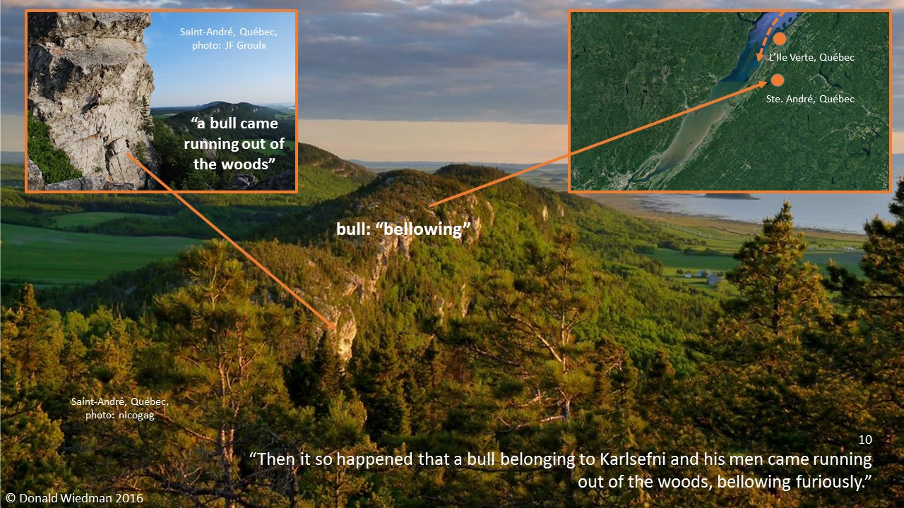
“Then it so happened that a bull belonging to Karlsefni and his men came running out of the woods, bellowing furiously.”
Here, past Ile Verte at about Ste. Andre, Quebec, a beautifully curvy palisade erupts out of the trees between the Appalachians and the fertile St. Lawrence shoreline flatlands. A “bellowing bull” comes to mind when looking at the unique characteristic of the cliffs. Local climbers today call the rock face “Moby Dick”.

“The Skraelings were terrified and ran to their skin-boats,”
Here, the aforementioned skin-boats (waving sticks at Gaspe and La Tourelle) reappear in the Saga. The word “ran” used to reference the “run” or ‘continuous stretch‘ of flat, fertile farmland stretching along the St. Lawrence River shoreline. The “skin-boats” represent the dozens of long, thin, low-lying islands, there in the St. Lawrence River estuary.

“and rowed away south round the headland.”
To end this oral map, the “red cloth” Saga introduces the word “away” – directing navigators to head toward Isle aux Coudres, across the River at the St. Lawrence Valley’s thinnest crossing point. Then head down the opposite coast until you meet the second “headland” – Cap Tormente, Quebec – and go “round” it.
At Ile d’Orleans, the current strengthens significantly as one passes between the island and the Quebec mainland, so the Saga directs sailors to get ready to “row” their ship, upriver to the destination: a deep, quiet bay at the mouth of the St. Charles River below Quebec City) where Jacques Cartier moored his ships in 1534 and 1535 (4).
Considering the numerous near perfect matches between The Vinland Sagas’ descriptions and the natural landmarks and landscapes between Newfoundland and Quebec City – it looks, and sounds, like Thorfinn Karlsefni might have moored his ships in that same bay at the mouth of the St. Charles River too, circa 1010AD!
– fin –
Donald Wiedman
Toronto, Canada
* * *
Footnotes:
The Voyages of Jacques Cartier – Ramsey Cook, University of Toronto Press, 1993
- “During that time there arrived a large number of savages.” – Jacques Cartier’s First Voyage, 1534, page 24
- “One passes an island some five leagues to the east, with no passage between it and the mainland.” – Jacques Cartier’s Second Voyage, 1535, page 47
- “He wore about his head for a crown a sort of red band.” – Jacques Cartier’s Second Voyage, 1535, page 63
- “We thought this river a suitable place in which to lay up our ships in safety.” – Jacques Cartier’s Second Voyage, 1535, page 50

Is it possible they also used hide boats too???
Yes, ‘skin’ boats could apply to both hide boats (Inuit kayaks in Labrador, Baffin Island and inside Hudson Bay), and bark canoes (Mi’kmaq and Iroquois in New Brunswick, Nova Scotia and Quebec).
In the Vinland Sagas the ‘boats’ double-entendre speaks of those natives’ boats, and also flat, low-lying islands (skin boats), the ‘skin’ being the turf atop of the island. The Sagas (and Jacques Cartier’s journals) also speak of natives sleeping on the beach under their ‘boats’ – these are likely rock islands (across from the mouth of the Saguenay) looking very much like overturned canoes.
How about a satellite search of the area you describe. Even a few nails from a Drakken would be compelling and findable with a metal detector.
Just a question , I’ve always heard rumors of Norse sites in the Grey County Highlands in Ontario. That would put them even further inland to the Great Lakes area .
Yes Dan, by my interpretations, the Norse travelled and mapped from Laval, Quebec up the Ottawa River. At Mattawa, Ontario they then row west (the Norse South), to “cliffs” where is now North Bay, Ontario. From there the Sagas instruct Norse settlers to “take a resolute stand” meaning they must (like they did deep into Russia) portage and row between a series of lakes and rivers. Upon reaching the French River, they can then clearly sail all the way west through Lake Huron and across Lake Superior to Minnesota.
The Kensington Rune Stone collaborates my interpretation. Upon it, it instructs one to head home to Greenland by travelling 14 ‘days’ back to where large ships can be safely moored. 14 days = 2 weeks = the length of two rivers (1 week = 1 river’s length). The first river heading back east is the French/Mattawa waterway, the second river being the Ottawa River, which takes you back to where they started: Lake of Two Mountains (Oka, Quebec), where the Ottawa River flows into The Riviere des prairies, which flows past the island of Laval and joins the mighty St. Lawrence River.
Thanks for your comment Dan; I really appreciate it!
Donald Wiedman
Yeah, it’s a good story, but it has too many holes when you compare the Vinland Sagas with archaeological evidence and a little common sense. I think the old saying holds true that the simplest explanation is often then best one. Your theory, while entertaining, makes some great stretches, and I assume that you are not very familiar with Newfoundland pre-history, in particular the Beothuk. They are almost certainly the skraelings. That would certainly make more sense. Also In the Sagas, They reached Straum before Hop and not the other way around. How do you account for this discrepancy? While I have no doubt that the Norse traveled further than they are given credit for, and they may have very well reached the places you say they did, the actual events in the Vinland Sagas almost certainly take place in Newfoundland and the evidence and common sense points to that conclusion. Also, to use the Kensigngton Runestone as part of your interpretation of Norse history makes it hard to take the whole thing seriously at all. The stone has been thoroughly debunked. Even though I admit that it is not impossible that the great explorers traveled that far, the evidence you have provided certainly does not back it up at this point.
Thanks for your comment Ryan: Yes I agree, the Beothuk of Newfoundland were the Skraelings in the Sagas, as were (also) the Mi’kmaq of New Brunswick, and the Iroquois of Quebec. I do my research… google “Mary March” when you have a chance. And check out my Facebook page to see my research including the Beothuk.
Unfortunately, you are misguided (too singular) about the order The Norse arrive at Straum (Ile d’Orleans, Quebec) and Hop (Barachois, Nfld). Leif Eiriksson arrives at Hop first, actually Green Gardens a little up the west coast of Newfoundland. It is not until Thorfinn Karlsefni tries to establish a permanent settlement there does he name the location ‘Hop’.
Simply put – and confirmed with Captain Ahlander of the Draken Harald that sailed up the St. Lawrence River this summer – it is basically impossible to explore by sail and rowing, up the St. Lawrence River from Greenland and home again in the same sailing season (without a motor). You will get stuck in the Canadian winter and (almost) starve to death. Because of Atlantic winds and currents, you can’t leave Greenland early enough in the spring to get settled safely inland, up the St. Lawrence River.
So, as the Sagas say a number of times, you must first head from Greenland to Newfoundland, and ‘winter’ there, then leave ‘Hop’ the next spring. Head up the St. Lawrence River (continue exploring) only after the spring thaw begins. The controversial Vinland Map (also curiously debunked, just like the Kensington Rune Stone, eh) states that Leif arrived in Vinland “amidst the ice” (floes).
Read the Sagas a little closer Ryan, and you’ll find too that when Karlsefni and Thorhall the Hunter later leave Straum (Ile d’Orleans) for home, they pass by Kjalarness (Gaspe) and then Hop (Newfoundland) on their way to Greenland/Iceland. Unfortunately, Thorhall the Hunter chooses to exit the Gulf of St. Lawrence via the Cabot Strait (Karlsefni takes the Strait of Belle Isle), and poor Thorhall ends up caught in the Gulf Stream, landing in Ireland instead!
Thanks again Ryan! Much appreciated!
Donald Wiedman
About the winter issue… And the time it takes to travel back during the warm season…. It is said in the sagas that Erik the Red was bannished for 3 years from Iceland… He used that 3 years to explore Greenland…. Surely to survive 3 winter seasons on Greenland is harsher than a few winter survival in Quebec. Is it possible that we are underestimating the skills and the abillities of those north mans ? I agree the the Baie de Gaspe would surely be very attractive to any new comers to stop and take a look. Especialy for water. I would look also into the baie des chaleurs south of gaspesian peninsula. The micro climate there could have attracted an certain interest in those visitors.
In the sagas there is mention of a one footer that shot an arrow at Thorvald – Is there a geological feature to explain this?
Ah the Vinland ‘Uniped’… Yes, I do believe I have interpreted that one. The story of Thorstein (not Thorvald, he get’s shot by a Skraeling) and the Uniped is a nautical map from west coast Newfoundland (from Hop inside St George’s Bay), out into the Gulf of St. Lawrence, and around the south side of Les Iles de la Madeleine. Les Iles is the object that ‘glitters’ in the Saga that gets Thorstein’s attention (Les Iles are the glittering ‘treasure’ or ‘hoard’ of The Gulf, still today).
The first time the Uniped appears, beyond the glitter, is a reference to ‘Deadman’s Island’ a landmark long-and-thin (Skraeling/Uniped with one foot, or pointe) island just wast of Les Iles. From there, they ‘give chase’ around the headland (aim for the Gaspe Peninsula) and then up the St. Lawrence River. Heading up the St. Lawrence they ‘catch glimpses of him’ from time to time, meaning the ‘oral map’ (story) lays out the many long-thin islands ahead, all the way up the St. Lawrence River to Laval, Quebec, and the Riviere des Prairies.
Thorstein ‘sitting at the helm of the ship’ is a reference to the same spot on the Riviere des Prairies that Thorvald is shot (Laval is the ship)(the arrow is the arrow-shaped Ile aux Chats)(Some say Thorvald and Thorstein are the same person). Interestingly, both stories/oral maps (Thorstein and Thorvald) then take you around the back of the Island of Laval (Riviere des Mille Iles). But, Thorstein’s ‘Uniped’ map continues east downriver (back tracks) with the creature disappearing south, out of sight; ‘some saying’ the Uniped heads home to Africa…
This final flight (on one foot, but a Uniped also has wings), is another Norse oral map that leads from the eastern tip of Laval, south, down the Richelieu River at Sorel, Quebec. The Richelieu then joins Lake Champlain, which then joins the Hudson River… all the way to Manhattan, NY. From there, you just need to sail out to sea to catch the Atlantic Ocean currents to Africa. (Note: if you head out the Gulf of St. Lawrence via The Cabot Strait you will catch the currents to Ireland (like Thorhall the Black does in another Saga/oral map). Out the Strait of Belle Isle will take you home to Greenland (like Leif does on his original voyage home from Vinland).
Just took a look at Les Iles de la Madeleine – The shape of southern end of the island actually looks like a foot. Interesting!
And the toe of the foot looks like a Canada goose, taking flight! https://www.facebook.com/lavalhallalujah/photos/a.412372382192575/866739673422508/
Vinland is Oak Island / Nova Scotia.
I just ran across this post doing some research for a novel I am working out. This is totally fascinating. I’m searching for Native tribes from the era. I see you mentioned the Iroquois and another. That might help me a lot. I shall bookmark this and the following blogs for reference.